PRODUCT DESCRIPTION
CORE TECHNOLOGY
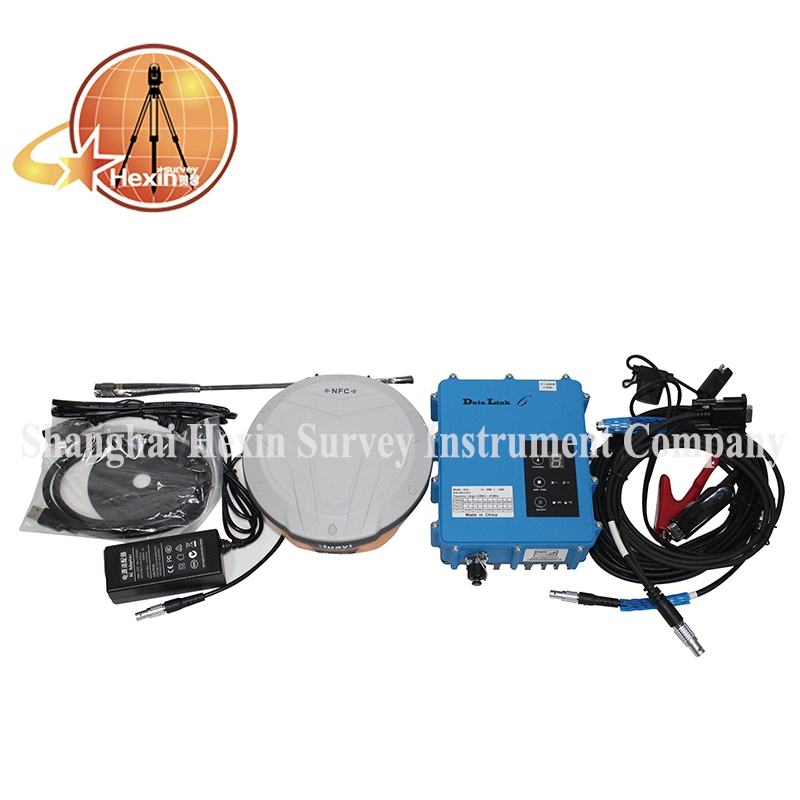
 | *624 Channels-Full GNSS High precision tracking of GPS, Glonass, Galileo, BeiDou and SBAS. *Internal 10200mAh Battery Internal 6800mAh battery, E91 can work up to 16h as RTK rover station under ideal conditions. *Internal 4G Network modem Embedded 4G modem for stable network RTK connections. The E91 can also be set as WIFI hotspot for the controller to access the Internet
|
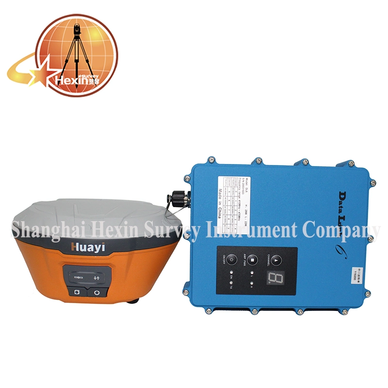
*Integrated UHF modem E91 intergated UHF modem can be set at frequencies between 410MHz-470MHz with up to 5km working range. *Rugged Design The rugged and durable design meets the IP67 environment standard for water and dust. The E91 CAN survive a 2m drop onto concrete. |  |
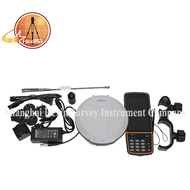
PRODUCT SHOW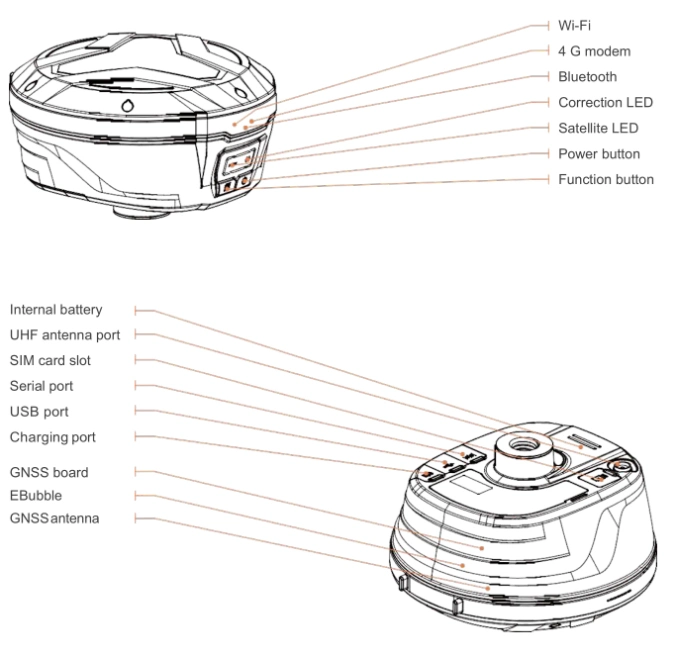
PRODUT SPECIFICATION
| GNSS | Channel | 624 |
| Signals | BeiDou B1, B2, B3; GPS L1, L2, L2C, L5; GLONASS L1, L2; GALILEO E1, E5A, E5B; QZSS L1, L2, L5; SBAS L1 | |
Accuracy | Post-processing Static | Horizontal 3mm±0.5ppm RMS Vertical 5mm±0.5ppm RMS |
| RTK | Horizontal 3mm±0.5ppm RMS Vertical 15mm±1ppm RMS Initialization time:<10s Initialization reliability:>99.9% | |
| PPK | Horizontal 3mm±1ppm RMS Vertical 5mm±1ppm RMS | |
| Code differential | Horizontal 0.4m RMS Vertical 0.8m RMS | |
| Autonomous | Horizontal 1.5m RMS Vertical 3.0m RMS | |
| Positioning rate | Up to 10 Hz | |
| Time to first fix | Code start: <45s Hot Start: <10s Signal re-acquistion:<1s | |
| Hardware | Size(L×W×H) | 160mm×158mm×96mm(6.3in×6.2in×3.8in) |
| Weight | 1.55kg(3.4Ib) with battery | |
| Humidity | 95% | |
| Work Temperature | -40ºC~+65ºC (-40ºF~+149ºF) | |
| Storage Temperature | -40ºC~+75ºC (-40ºF~+167ºF) | |
| Tilt Sensor | E-Bubble leveling | |
| Ingress Protection | IP67 waterproof and dustproof, protected from temporary immersion to depth of 1m | |
| Shock | survive a 2-meter pole drop | |
| Front Panel | 4 status LED | |
| Communications & Data Recording | UHF Radio | Standard internal Rx/Tx: 410MHz to 470MHz; Transmit Power: 0.5W to 2W; Protocol: CHC, transparent, TT450; Range: 5km optional conditions |
| WIFI | b/g/n, access point mode | |
| Network modem | integrated 4G modem | |
| Bluetooth | V4.1 | |
| Ports | 1×7-pin LEMO port(external power, RS-232);
1×USB2.0 port (data download, firmware update) 1×UHF antenna port (TNC female) 1×2-pin LEMO port (optional) | |
Data Formats | CMR input and out put; RTCM2.x. RTCM3.x input and output; NMEA 0183 output; HCN, HRC and RINEX2.11, RINEX 3.02 NTRIP Client, NTRIP Caster | |
| Data Storage | 8GB high-speed memory | |
| Electrical | Battery Capacity | 10200mAh |
| Operating time on internal battery | RTK up to 16 hours | |
| External Power | 9VDC to 28VDC |
PACKING & SHIPPING

PAYMENT 
COMPANY INFORMETION
Shanghai Hexin Survey Instrument Co., LTD has 8 years' experience in geodetic surveying and cadastration surveying, we are a professional and leading enterprise in the surveying industry in MainlandChina. We specialize in the R&D and manufacturing and sales of all kinds of surveying products, including total station, electronic theodolite, electronic distance meter, automatic level, laser level, reflector prism, surveying accessory, GPS receiver, mapping software, etc.The marketing model advocated by us is not a simple sense of "selling products", instead, pre-sales service, services during operation and after-sales service are integrated in entire operating activities. It makes the customers feel that they purchased not only a commodity, but also a professional service.We welcome new and old customers from all walks of life to contact us for future business relationships and achieving mutual success!
FAQ
Q:How to turn off voice broadcast of receiver?
A: a. Enter the WEBUI, find the voice switch in the settings page and turn it off.
b. Controller Software→Device→Device Setting, turn off the "enable voice", and click"ok"
Q: Can the base station and rover station be interchangeable?
A: The difference between the rover station and the base station is that the accessories are different, the function and hardware configuration are the same.You can use the controller to choose the working mode of the device and set it as the base station or rover station.
Q: What is CORS?
A: CORS is called a continuous operating reference station system. It can be understood as a bas e station that is erected at a fixed known point and works continuously for 24 hours and sends its own data to a specific serverthrough the network. The use of CORS operation eliminates the need for a base station, and CORS is equivalent to a base station in a normal network operation.